Turn on Javascript


This website uses Javascript


Turn on Javascript
This website uses Javascript
Hello. Is the website looking too large? Click on the button below to make it a better size
When the new window is open, you can close this window

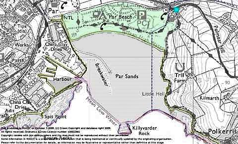
You can see the path on the map above, the beach also abuts The Saints' Way (blue dot and path running up the hill on the left - on map below). In Oct 2009, the Telegraph named The Saints' Way as no.2 in the top 5 pilgrim routes in Britain. The Saints' Way covers almost 30 miles from Padstow across to Fowey.
The area we are concerned with (shaded pale green on the map* above), loosely has the following boundaries:
North - The Imerys haul road.
East - Just below the cliff line - excluding the Ship Inn, which is privately leased from the Rashleigh Estate, and the privately owned property (formerly the Indian restaurant) which owns the freehold of their plot.
South - Mean high water. i.e. the position of the varying high tide level.
West - The Par River. (See the Westcountry Rivers Trust web page)
The area includes the local nature reserve and the brackish (meaning a mixture of saltwater and freshwater) pool known as Polmear Lake or the Bird Lake, the beach, the sand bar and dunes, the caravan park (privately leased from Cornwall County Council), the picnic area and the main car park (owned by the Rashleigh Estate). Excluding the caravan park site, this comes to just over 31 hectares.
The area sits on the Meadfoot Beds of the Lower Devonian - essentially various layers of mudstones, siltstones and sandstones or sandy siltstones. These are covered by alluvium (sediments deposited by flowing water) to the north of the sand dunes and with sands to the south. The soil is generally neutral to moderately acid.
The dunes are still building which is unusual in the UK as most sandy coastlines have retreated in the last 100 years. In fact the high tide mark moved about 100m towards the sea between 1885 and 1985. The dunes are an important flood defence, to the north of the dunes the low lying ground was sea until the sand bar formed at the end of the 1700s and was flooded regularly until the late 1970s.
The "Bird Lake" is a brackish pool which was once a model boating pond, it is connected to the sea via a sluice gate and a channel. It isn't shown on maps in 1870 but can be seen at half its present size, in aerial photographs taken in 1946. Brackish pools normally change over time to freshwater, but as there is the sluice gate (which is opposite the old car park toll hut) in theory at least, at the highest of tides, seawater can enter.
Paul Coon our local drone expert has some interesting views of the beach and surrounding area on his YouTube channel. You can view it below.
* Map produced by MAGIC, Ordnance Survey Licence Number 100022861
